Offline-Maps in Android: Diese Kartendienste funktionieren ohne Internet


Ob es am zu knappen High-Speed-Volumen, am teuren Daten-Roaming oder schlichtweg am fehlenden Empfang liegt: Offline-Karten fürs Smartphone sind oft praktisch. Google Maps lässt sich zwar offline nutzen, doch für Offline-Navigation eignen sich Drittanbieter-Alternativen besser. Im Update zeigen wir, wie sich die aktualisierten Versionen der OSM-basierten Offline-Karten schlagen.
Viele Kartendienste sind, anders als Google Maps, direkt auf die Offline-Nutzung spezialisiert. Denkt man an die ersten Navigations-Computer für Autos, erscheint das wenig verwunderlich. Die folgenden Apps könnt Ihr zu Hause im WLAN auf Eurem Smartphone einrichten und ihre Offline-Karten auf Eure lange Reise mitnehmen. Egal ob im Gelände oder in fernen Metropolen könnt Ihr so auch ohne mobile Datenverbindung navigieren.
Offline-Map-Apps im Schnellvergleich
| Here WeGo | Maps.me | OsmAnd | Trekarta | Google Maps (offline) | |
|---|---|---|---|---|---|
| Preis | Gratis | Freemium | Freemium | Freemium | Gratis |
| Karten | Here | OSM | OSM | OSM | |
| Auto-Navi | Ja | Ja | Ja | Nein | Ja |
| Fahrrad-Navi | Ja | Ja | Ja | Nein | Nein |
| Fußgänger-Navi | Ja | Ja | Ja | Nein | Nein |
| Öffentlicher Verkehr | Ja | Ja | Beta | Nein | Nein |
| GPS-Tracking | Nein | Nein | Nein | Ja | Nein |
HERE WeGo
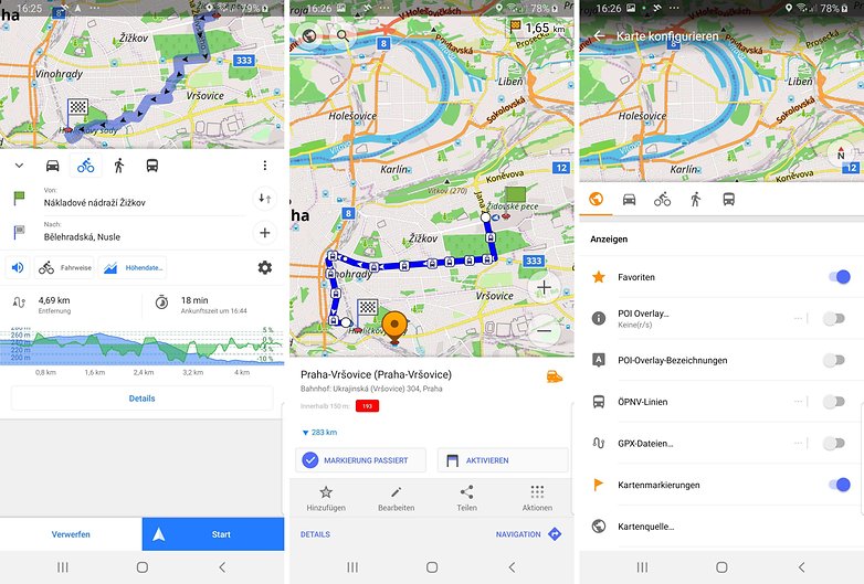
Bei HERE WeGo, ehemals HERE Maps, habt Ihr die Wahl zwischen Online- und Offline-Modus. Mit aktivierter Internetverbindung ruft HERE auch Verkehrsinfos in Echtzeit ab und manövriert Euch um den Stau herum. Im Offline-Modus greift HERE nur noch auf heruntergeladene Karten und Informationen zu. Und dazu gehört erfreulicherweise auch der öffentliche Nahverkehr.
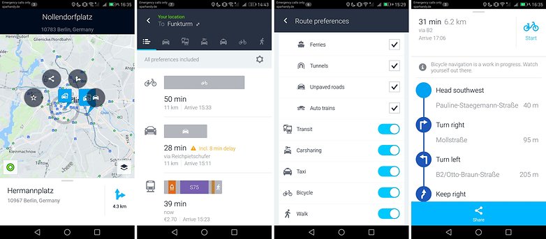
In vielen Großstädten habt Ihr Zugriff auf den Fahrplan der öffentlichen Verkehrsmittel. Außerdem könnt Ihr auch offline Routen für den Fußmarsch oder für die Anfahrt mit dem Fahrrad errechnen lassen. Das sind zwei schlagende Vorteile gegenüber Google Maps, das keine dieser Funktionen im Offline-Modus bietet.
HERE sortiert die Routenvorschläge mit unterschiedlichen Verkehrsmitteln nach ihrer Reisedauer. HERE WeGo will langfristig Car- und Ride- oder Bikesharing-Angebote in seine App integrieren, die Ihr dann direkt in der App buchen sollt. Natürlich ist dies dann nicht Teil der Offline-Funktionalität.
HERE ist auch als Navigations-App im Auto gut zu verwenden. Im Fahren-Modus wird auch die Betrachtung im Querformat ermöglicht. Natürlich gibt es eine Sprachausgabe für die Turn-by-Turn-Navigation. Und wenn Ihr zu schnell fahrt, gibt HERE WeGo auf Wunsch Warngeräusche von sich. All dies gelingt HERE We GO auch offline. Mit Internetverbindung informiert Euch das Navi zusätzlich über Staus und hilft Euch, sie rechtzeitig zu umfahren.
Die Navigation beim Spazierengehen liefert tolle Zusatzfeatures. In Shopping-Malls seht Ihr die Geschäfte aller Etagen innerhalb der Einkaufspassage. Draußen könnt Ihr per Wikipedia-Daten Sehenswürdigkeiten finden und ihre Beschreibung lesen. Dies erfordert allerdings wieder eine Internetverbindung. Offline-Navigation inklusive Offline-Wikipedia gibt es mit OsmAnd (unten).
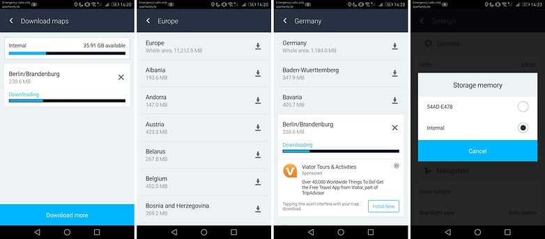
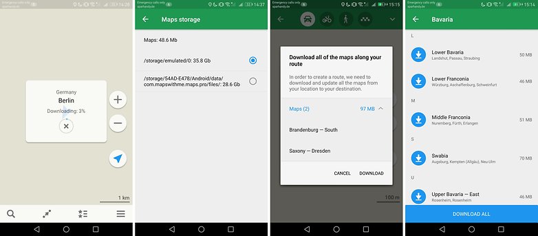
Die Offline-Karten sind zum Teil in Regionen wie Bundesländer gestückelt und oft mehrere hundert MByte groß. HERE WeGo bietet die Möglichkeit, die Daten auf einer Speicherkarte abzulegen.
${app-com.here.app.maps}MAPS.ME
MAPS.ME ist eine nichtkommerzielle Alternative auf Basis des offenen Gemeinschaftsprojektes OpenStreetMap. Seine Download-Funktion ist besonders nutzerfreundlich: Plant einfach Eure Route und die App sagt Euch dann von sich aus, welche Kartenausschnitte sie herunterladen muss. Der belegte Speicherplatz ist deutlich kleiner als bei HERE und eine teure Beschränkung wie bei OsmAnd entfällt.
MAPS.ME ist deutlich einfacher gestaltet als HERE und bedient sich schneller. Egal ob mit dem Auto, dem Fahrrad oder zu Fuß: MAPS.ME errechnet Euch flott offline die Route zum Ziel. Bei der Fahrrad-Navigation seht Ihr sogar schon vorher die Steigung auf der Route.
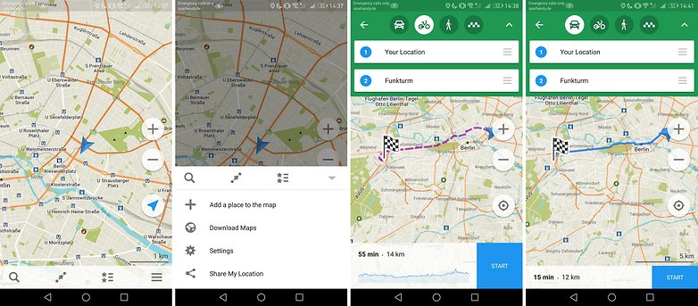
Die OpenStreetMap-Karten in MAPS.ME könnt Ihr auf Geldautomaten, Parkhäuser, Bushaltestellen und andere "Places of Interest" hin durchsuchen. Ähnlich wie in Google Maps findet Ihr Metadaten wie Öffnungszeiten, Telefonnummer oder Web-Adresse.
${app-com.mapswithme.maps.pro}OsmAnd
OsmAnd ist die wohl umfangreichste Android-App zum Betrachten der OpenStreetMap. Denn anders als MAPS.ME (oben) oder Trekarta (unten) scheint OsmAnd keinerlei Spezialisierung zu haben. Ihr könnt die Daten der Community-Karten in ihrer kompletten, überwältigenden Fülle durchforsten. Jeder Geldautomat, jede öffentliche Toilette und jede Bushaltestelle ist eingezeichnet.
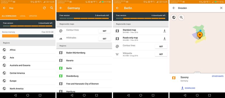
OsmAnd ist nicht ganz gratis. Nur eine begrenzte Menge Kartenausschnitte dürft Ihr gleichzeitig offline vorhalten. Danach wird ein In-App-Kauf verlangt. Das Gleiche gilt für Zusatzfunktionen wie die Wikipedia-Integration.
Neben der Karten könnt Ihr auch die Wikipedia-Einträge des Kartenbereichs für die Offline-Nutzung herunterladen. So ist die komplette Beschreibung der interessanten Orte (Places of Interest, POI) für Euch abrufbar, auch wenn Ihr am Reiseort nicht mit dem Internet verbunden seid. Diese Option ist leider nur in der kostenpflichtigen Version erhältlich.
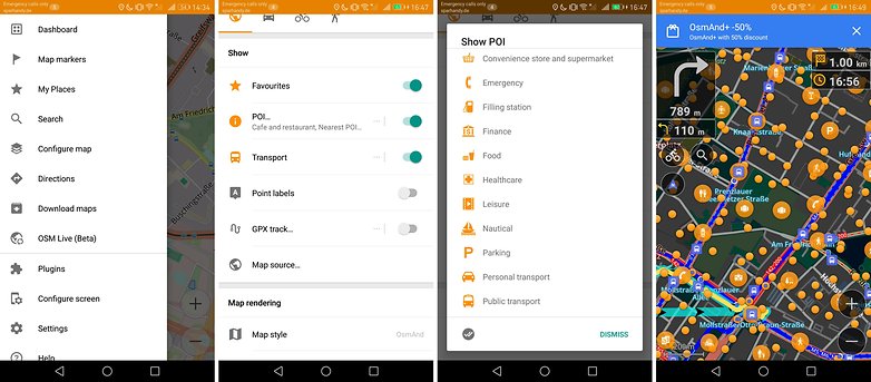
Insgesamt ist die App zwar umfangreich und für den gewaltigen Datensatz der OpenStreetMap gewappnet, wirkt damit jedoch oft überladen. Die Oberfläche wurde in den vergangenen Jahren deutlich überarbeitet, wirkt jedoch bei weitem nicht so poliert wie bei Here oder Maps.me.
Auch wenn sich die Punk-zu-Punkt-Navigation deutlich verbessert hat, kommt sie in Sachen Performance und Einfachheit noch nicht an die von Maps.ME heran.
${app-net.osmand}${app-net.osmand.plus}Trekarta Lite
Einen Use-Case hatten wir noch gar nicht betrachtet: Was, wenn Ihr Euch außerhalb einer Stadt bewegen wollt? Irgendwo in den Bergen, fernab der schnellen LTE-Verbindung? Oder mitten in der russischen Taiga, 1.000 Kilometer von der nächsten Stadt entfernt. Da kommt Trekarta ins Spiel.
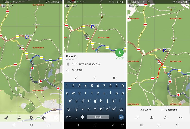
Denn das Kartenmaterial von OpenStreetMap erschöpft sich nicht in der urbanen Navigation. Auch unterwegs beim Wandern, Skifahren oder mit einem geländegängigen Wagen mit Allrad-Antrieb (4WD) helfen seine Daten. Trekdata zeigt entsprechende Steigungen, Pisten und 4WD-pflichtige Straßen an.
Routenplanung wiederum übernimmt die App nicht für Euch. Jedoch kann sie Eure Bewegung offline anhand Eurer GPS-Koordinaten aufzeichnen. So könnt Ihr abends noch einmal nachmessen, wie viele Kilometer Ihr an dem Tag auf der Piste oder den Wanderwegen zurückgelegt habt.
Fazit
HERE WeGo ist für Autofahrer eine fantastische Alternative zu Google Maps und bietet nicht nur offline deutlich mehr Funktionen als die Google-App. Das quelloffene MAPS.ME hat sich im Laufe der Jahre jedoch zur vollwertigen und sogar schlankeren Alternative entwickelt. Wer die komplette Fülle der OpenStreetMap offline auf dem Smartphone ausschöpfen will, braucht OsmAnd. Geht es Euch hingegen eher darum, Eure ohnehin schon gut geplante Wanderung zu begleiten, ist Trekarta Euer Freund.


Habt ihr die Möglichkeit, dazu nochmal einen aktuellen Artikel zu schreiben?
Es gibt bestimmte Standards, die einzuhalten sind, damit ich eine App sinnvoll nutzen kann.
1. von Funktionen abgesehen, die technisch nicht ohne Internet funktionieren können, wie z.B. Tracks während der Fahrt aufzuzeichnen, müssen die Apps offline volle Funktionalität bieten.
2. der Nutzer muss volle Kontrolle über die Nutzung der App haben.
3. Die App darf Geld kosten. Aber es darf kein Mietmodell sein. Man kann nicht für eine einmal erbrachte Leistung lebenslang Geld verlangen.
4. Die App muss ohne Konto in vollem Umfang nutzbar sein.
Wenn beispielsweise bei GARMIN Routen nur noch in GARMIN Connect mit Anmeldung und Konto erstellt werden können, dann kann ich mir das Geld für GARMIN-Geräte, wie zum Beispiel "GARMIN EDGE EXPLORE - GPS-TOURENRAD-NAVI" sparen.
Zitat aus dem Handbuch: "GARMIN EDGE EXPLORE - GPS-TOURENRAD-NAVI": "Sie können eine Strecke aus Ihrem Konto bei Garmin Connect an das Gerät senden." Die merken doch nichts mehr.
5. Es müssen tracks im Standardformat *.gpx gespeichert und geladen werden können, um diese tracks mit anderen Programmen, zum Beispiel auf dem großen Computer austauschen zu können.
6. Es müssen gute Kartendaten, wie beispielsweise die OpenStreetMaps auf das Smartphone geladen und natürlich offline genutzt werden können.
Habe mir gerade die Here App installiert. Die Auswahl Fahrrad bei der Navigation habe ich nicht vorgefunden. Es gibt nur Auto, zu Fuß und mit öffentlichen Verkehrsmitteln.
Sollte ich eine bessere Alternative finden, dann fliegt die Here wieder runter.
Im Offline-Modus kann man nur auf die Karte schauen, die aufgrund der mikrigen Darstellung und jedem Fehlen von Radwegen, Sehenswürdigkeiten und anderen wesentlichen Dingen unbrauchbar ist. Offline ist navigieren nicht möglich.
Nun könnte jemand einwenden, dass man ja eine Flatkarte nutzen kann. Ja kann man. ich will die Karte aber auch dort verfügbar haben, wo es mit der Funkverbindung nicht so dolle ist. Außerdem geht es niemanden was an, was ich gerade auf der Karte mache.
Also - war wohl nichts. Ich habe es jetzt wieder deinstalliert.
------------------------------------------------------------
Nun die Maps.me
Gute informative Karten und kann offline routen - schickt allerdings die Radfahrer über die Autostraßen. Die Ergebnisse von Google Maps sind besser, funktioniert allerdings nur online.
----------------------------
Locus Map 4 Outdoor-Navigation
Wollen Zugriff auf Medien, verlangen Zustimmung zur Aufgabe des Datenschutzes - und wollen in der ProVersion dafür auch noch bezahlt werden. Leider nichts für mich. Sofort wieder deinstalliert.
------------------------
zuletzt habe ich mir OSMand vorgenommen.
Karten gut, Routen gut, man kann gpx-tracks + POI ex- und importieren, wenn auch nichts sonderlich elegant. Kartennutzung auf 7 Dawnloads beschränkt. Ist aber OK. Dabei werde ich erstmal bleiben. Wenn es sich bewährt werde ich weitersehen.
Maps.Me habe ich vor Jahren schon als Wander-Navi benutzt. Damals gab es noch eine offline Karten bei Google Maps und die Roaminggebühren waren entsprechend hoch. Von den Details der Karten war ich begeistert. Da waren Wege eingezeichnet, die Google Maps nicht kannte. Vielleicht muss ich mir nochmal anschauen, was bis heute draus geworden ist.
Noch nie was anderes als here verwendet, hatte es schon zu meinen Windows Mobile Zeiten.
Benutzt in : Kanada, Israel, Thailand, Bermuda, Dom Rep., Ägypten und so weiter und so fort.
Dort auch immer offline und immer gut. Kartenaktualisierung immer gratis und weltweit. Noch Fragen?
Ein Navi ohne Internet? 😁👍Bin selbst Baujahr 1981 und habe immer noch meinen DDR Atlas von 1977, der macht auch heute noch seine Arbeit, wenn auch nur für den Bereich DDR. Aber für den Urlaub an der Ostsee reicht der Blick immer.
Glückwunsch Karsten😊
Für die DDR nur.... aber die Karten sind erstaunlich aktuell im Jahr 2019. War im Februar in Dresden und habe den Stadtplan vom Atlas dazu benutzt, aus Gaudi mal. Auch Leipzig ist dort drin vertreten wie ganz Berlin, mit Verlauf der Mauer zum Westen. Sollte mal kein Internet sein oder Akku schwach, ist so ein Atlas immer noch hilfreich.
Ich nutze seit Jahren Navigon und bis jetzt habe ich keine App gefunden, die Navigon das Wasser reichen kann.
Navigon wurde doch eingestellt aufgrund fehlender Absatzzalen . Gibt weitaus bessere kostenpflichtige Navi Apps.
Ja und? Die App läuft ja weiter und Kartenmaterial ist auch vorhanden. Und warum kostenpflichtig?
Ich benutze inzwischen seit einigen Jahren Google Street Maps, Here we go und OsmAnd+ und kenne deshalb auch die Entwicklungsschritte der Apps. StreetMaps ist inzwischen in den allermeisten Fällen mein Favorit fürs Autofahren - ich habe mehrfach die üblichen großen Staus um München über Nebenstrecken durch völlig unbekannte Dörfer in Bayern spielend umfahren und viel Zeit gespart. Für Wander- und Radtouren oder das Auffinden von Parkplätzen, Toiletten usw. ist OsmAnd+ einen Tick besser. V. a. die Wanderkartenfunktion ist selbst bei Bergtouren genial und eben offline zu nutzen. Gleiches gilt natürlich auch fürs Navigieren und Orientieren im Nicht-EU-Ausland, wo ich mir problemlos die notwendigen Karten regionen- und nicht länderweise vorher zuhause runterladen kann. Das kann auch Here we go, Navigation ist sehr komfortabel, nur das Herunterladen und Aktualisieren der Karten meist etwas zeitaufwendig und mitunter nach Wiederholung schreiend. Ebenso braucht Here... viel Ressourcen. Läuft es einmal, ist es ziemlich gut, auch wegend der Geschwindigkeitswarnung, die übrigens OsmAnd+ auch kann. Die ideale App gibt es meiner Meinung nach nicht, weshalb ich nach Bedarf "switche". Im Übrigen halte ich die paar Euro für OsmAnd+ für voll gerechtfertigt. Ich benötige kein Navi mehr und kann bei Bedarf die dank OpenStreetMaps aktuellsten Karten und Zusatzinformationen jederzeit bekommen - für die gängigsten Regionen der ganzen Welt!
Ihr habt MagicEarth vergessen.
Kostenlos, Offline Maps (OSM) und einen sehr netter Support.
Es gibt noch eine ganze Menge weiterer Apps, die offline funktionieren (siehe meine Übersicht unter https://android.izzysoft.de/applists/category/named/travel_positioning_navigation und drücke dort "Strg+F" plus gib "offline" ein) – nicht alle passen in den Artikel. Ich denke da beispielsweise an Locus Map (in den Kommentaren nun schon seit 4 Jahren erwähnt), AzNav, Navigon, Trekarta … und meine Liste ist bestimmt nicht vollständig (vielleicht fehlt sogar bei der einen oder anderen App der Hinweis, dass sie auch "offline kann").
Von Mapy.cz hat wohl noch keiner gehört? 42 Länder, Offlinekarten, Tracking möglich, einzelne Länder sogar nur Region auswählbar. Läuft zum wandern, Radfahren, Autofahren. Karten runterladen und gut ist. Komplette Offlinenavigation. Nutze ich seit Jahren....
Hallo Karsten,
dann fahre mit deinem Atlas besser nicht nach Holland. Was dort in den letzten Jahren an Straßen um / neugebaut wurde, ist schon irre. Allein im Gebiet Venlo schon.....;)
War ich schon...slagharen Freizeitpark fast jedes Jahr seit 1996 und ostseecamp seeblick meschendorf seit kindheit
Hallo zusammen,
ich nutze nun ca. 4Jahre HERE, aktuell auf Huawei Nova plus, davor auf Nokia 920 Windows.
Was anderes als Here kommt mir nicht aufs Gerät. Immer frische Karten, flüssiger Lauf, keine Hänger. Auch offline in weit entfernten Ländern immer gut funktioniert. Zumindest meine Erfahrung.........
Benutzt noch jemand einen guten alten Atlas?... Ich hab noch einen von meinen Eltern aus den 70er Jahren und erfreulich wie aktuell der immer noch ist
-
Admin
06.05.2018 Link zum KommentarAktuell aber nur noch in der Straße, in der Du mit Deinen Eltern wohnst, oder?
Nee mein freund hab eigene Wohnung😁🍺